Sunday, October 20, 2019

Odds & Ends


This post is just some fun pictures that we just didn't have room for in our newsletter.

Presedential elections were last week.  In the weeks leading up to election posters were plastered everywhere and we would come across political rallies complete with flags and megaphones.  Voting day was a holiday to ensure that everyone has a chance to get to their respective polling stations to vote.  After voting, the voter's finger is dipped in indelible ink so they cannot go vote at another location.  The next morning when we arrived at work, we asked our guard, Amisse, if he voted and he showed us his finger.


In addition to our normal flight schedule, maintenance, and routine work occasionaly we have a change in the routine.  In this case we coordinated with the airport fire fighters to make sure all of our staff were trained to use our fire extinguishers.

Fire Extinguisher Practice

Sometimes local preschools take a field trip to the airport.  The kids always enjoy taking a look inside our aircraft and sitting up front and imagining being a pilot.

Pre-schoolers on a field trip to the airport gets a tour of our airplane


Dave recently flew to the Niassa Reserve and had to spend the night at the camp because it was too late in the afternoon to fly back to Nampula.  To get to the camp, they had to take a canoe across the river.  Early the next morning they paddled back across the river to the airstrip so he could fly back to Nampula.


For all of my Department of Transportation friends:  Here are a few pictures of some pothole repair in the city.


In August we had some family members come to visit.  We started out their visit with a day trip to Kruger National Park.  In our past visits, we had seen all of the Big 5 except the leopard (lion, cape buffalo, elephant, and rhino).  This time we saw THREE leopards.  So awesome!!  We also saw some other animals we had never seen making the day pretty special!

Leopard No. 1 walking straight towards us

Hyena cub

African Open-billed Stork near a crocodile

African Spoonbill, Yellow-billed Stork and Hippos

Secretarybird (not a great pic but super exciting to see!)


We also did some hiking and visited a bunch of waterfalls in South Africa.

Hiking at the Three Rondavels


Rock hyrax


After our time in South Africa, they returned to Mozambique with us for a week.  We went on a hike in Rapale and then visited Ilha de Mocambique.

Hiking at Rapale (we made it to the top of that tall mountain ahead of us)

Tour on Ilha

Ilha de Mocambique

A few bonus wildlife pics:
Leopard No. 1

Leopard No. 2


Zebras and impalas at a watering hole

Black-backed Jackal
Elephants crossing a water hole
  
Lazy lion

Lazy hippo

Chill Croc


Black-headed Gonolek (seen in Uganda)


Tuesday, July 2, 2019

Cyclone Kenneth


Less than a month after we returned to Nampula from Beira, helping out with the Cyclone Idai response, Cyclone Kenneth hit north of the city of Pemba (north of Nampula).  Kenneth is considered the to be the strongest Cyclone to hit Mozambique in modern recorded history.  Again, MAF immediately deployed DR team members ahead of the storm so that we could send the Caravan to Pemba the day after the storm struck the Mozambican coastline.  We were the first aircraft to arrive on the scene.  The next day, an aerial survey was completed to survey and map the affected areas to share with the government and the responders coming to aid affected people.  It was apparent that islands of Ibo and Matemo were quite hard hit as well as multiple villages on the mainland.

Getting ready for the survey flight and visit to Ibo Island (L. Hibberd)

Survey Photo of destruction (J. Gorenflo)

Damage at Mecujo

That same day, the team walked around Ibo Island to talk to the residents and survey the damage.  There were no communication services on Ibo which made it difficult to coordinate aid efforts. Learning the lesson from Cyclone Idai, MAF chose to send its VSAT (high speed satellite data communication) equipment to Mozambique for Cyclone Kenneth and after this visit decided it would be put to use best on Ibo.  On a future flight the equipment was brought to the island and set up by MAF's expert, John G.  He stayed on the island and helped connect the constant influx of aid workers coming and going to the island.  Later after John left, another MAF tech guy, Lukas, came and continued to make sure the equipment was operational.  They also help coordinate passengers and cargo as it arrived on the island.

Dave showing Ibo Island residents pictures on the iPad (R. Emenaker)


John G. with the VSAT equipment (L. Hibberd)
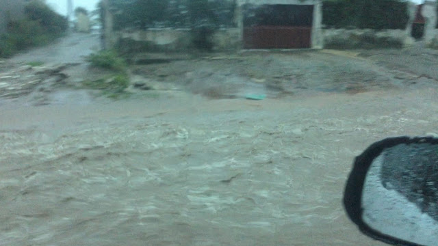
The day after the survey brought frustration as rain dumped on the city of Pemba.  It rained over 22 inches in just four days.  On this day it was coming down so hard it was impossible to fly and even difficult to drive between the hotel and the airport.

Pemba roads flowing with water after the storm (D. Holmes)

Finally, after a break in the weather, our Caravan was able to start delivering aid, including shelter and food, to Ibo Island.  At logistics meetings and through coordinating with INGC (Mozambique's disaster relief branch) and aid organizations, we were able to come up with a plan for the coming weeks.  The road to Macomia was open and accessible by vehicle so we decided that our Caravan could be better put to use serving the affected islands that have airstrips. 

Unloading High Energy Biscuits (D. Nguyen)

 
Time-lapse film of flight between Ibo and Pemba (Sandra Black)

A bookings phone number, email, and form were set up so we could offer regular shuttle flights between Pemba, Ibo, and Matemo.  There was a morning and afternoon shuttle for passengers with space between for cargo flights and additional passengers as needed.  We also partnered with a local organization to transport family kits of food to Ibo every time there was empty space on the plane.  You can read more about this on MAF's storyhub.

Here is a GoPro video Dave recorded flying from Pemba to Ibo Island.  Check out the beautiful coastline and the awesome shortfield landing!

We also flew two more aerial surveys.  One was to examine the wider area and make sure the government was aware of all of the smaller affected villages.  The other was to look survey roads and powerlines for the public works department.  We photographed numerous bridges washed out and created another map with geo-referenced photos.  

One of numerous bridges washed out (J. Holmes)
We flew shelter supplies, food, school supplies, communications equipment, medical supplies/medicine, and chainsaws for clearing downed trees.  Workers went to assess needs and for the purposes of food security, health, shelter, hygiene, education, protection, and communications.  One morning the wife of the governor (of the affected province) came out to the airport and was thanking some of the aid workers for their work in the response.

Jill with the wife of the Governor


Time-lapse video of a landing at Ibo


Over the three week period we flew:
29.6 metric tons of cargo
469 passengers
111 flight legs
Served 24 organizations

 Our VSAT equipment served:
11 organizations 
over 60 users